Redding boasts some of the most premier outdoor opportunities of any city that I have ever been to. There is so much to do and see in every direction. One of my favorite day trips in the area is a waterfall tour visiting Potem Falls, the three McCloud River Falls, and Hedge Creek Falls. It makes for a fun day with friends or family, takes you through some of the most iconic landscapes and vistas in UpState California, and lets you return back to your Redding hotel to rest up for another day of adventure.
Bring a camera to snap a few shots, but before heading to the next spot take a few minutes to enjoy the beauty before you. Look at the intricacies of each of the falls, and the landscape around it. Listen to the sounds of the water, and the birds singing. The smells of Northern California coniferous forests surrounding you. People travel all over the world hoping to encounter something as beautiful as what you will see at every stop on this incredible trip.
Potem Falls
The first stop on your trip is Potem Falls, about an hour drive. The waterfall lies in a deep canyon and falls 45 feet into a pool at the base below. Enjoy swimming in the pool at the base during the summer months, and don’t forget to check out the rope swing!
Directions: Head out on CA Highway 299-E toward Burney, then take a left on Fenders Ferry Rd. Drive down Fenders Ferry Rd to reach the Potem Falls trailhead.
McCloud River Falls
From Potem, you continue to the three McCloud River Falls. There are several access points, and if someone wanted to opt out of the hike they could drive to each one. I highly recommend doing the hiking loop as it will take you along the McCloud River and through the forest to each of the three falls - Lower Falls, Middle Falls, and Upper Falls - each unique. It is only about a 1-mile hike each way from the Lower Falls to Upper Falls, and is really easy.
It’s a short and easy hike to see Lower McCloud Falls and Upper McCloud Falls – both are ADA accessible with a paved trail from the parking lot. The lookout point for Middle McCloud Falls is above the waterfall but there is a short hiking trail to the right you can take to get to the base of the waterfall and connect with the main trail that connects all three waterfalls.
Directions: Continue on CA-299 through Burney where you can stop for gas, food or load up your cooler at the grocery store for a waterfall adventure picnic. and head to the three McCloud River Falls – Lower, Middle and Upper. Just north of Burney, connect with CA-89 north for about 40 miles. You will see signs for Fowlers and Lower Falls campground in the Shasta-Trinity National Forest.
Lower MCCloud Falls
This is the lowest of three levels of the McCloud River Falls, at a 12 foot broad plunge into a large pool. Surrounding the pool are large rocks perfect for sun bathing, making this location popular for swimming and relaxing.
Middle McCloud Falls
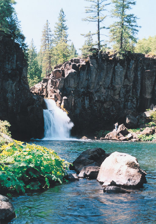
This is the middle of three levels of the McCloud River Falls and is the largest and most impressive with a 44 foot drop providing a magnificent view. This waterfall is one of the widest in California at 120 feet, creating a veil of white water during spring and reducing to become two separate but uniform cascades in later seasons.
Upper McCloud Falls
The tallest of the three McCloud Falls, it escapes a narrow gorge to crash down small steps to its base, where a beautiful aquamarine pool will catch your attention.
Hedge Creek Falls
After you leave the McCloud River Falls, head west through McCloud and Mount Shasta to Interstate 5 South to Hedge Creek Falls (22 miles, 27-minute drive). Hedge Creek Falls is about a 5-minute easy hike to the falls that sits in a canyon and offers a small cave behind the waterfall, allowing you to walk behind the cascading water for a different perspective.
Directions: Take I-5 South, exit 732 to Dunsmuir Ave/Mott Rd and take an immediate right and park to the right. Safely cross the street on foot and you arrive at the trailhead.
The short 45-minute scenic drive back to your Redding hotel is enjoyable with through the Shasta-Trinity National Forest, offering views of Castle Crags State Park, the Sacramento River, and Shasta Lake. So, crank the tunes and reflect on the perfect day you just experienced in UpState California.
REDDING’S WATERFALL LOOP
Driving Directions: https://goo.gl/maps/1ro4uGdwTubxQETY8
Total Distance: 197 miles
Total Time Driving: 4 hours, 9 minutes