On the morning I left Visalia CA (Friday, July 20), I had no idea if my long-planned next stop of Mammoth Lakes would be smoke-clogged or clear with some haze, or large unaffected. Thankfully, it was the latter, a best-case scenario. It was glorious out the whole weekend I was there, really.
The weather just wasn’t great on the way in. To the contrary, I faced some heavy thunderstorms just outside of Yosemite. And then I spent at least three hours of driving through smoky and, after a bit, hazy surroundings in Yosemite, especially in Yosemite Valley. The less said about that, the better. It was so smoky, really, that I had to manipulate a photo of Half-Dome to degrees that made the shot look like it was from 1875, just to get it to look halfway decent.
I managed to get another OK shot of Bridalveil Fall as well, one I processed to within an inch of its life to make it look decent. Even when I took this, however, there was quite the crowd around, although I noted later than the parking lot at Half-Dome (Curry) Village, where I had earlier planned to stay on Wednesday and Thursday nights, was only about half full on a weekend.
Things improved about an hour-and-a-half of driving on Tioga Road, which runs through Yosemite's high country, in the Eastern Sierra. It was still hazy, however, and getting dark as thunderstorms approached. A few minutes after I made it out of the park, the heavy rain and lightning started.
By dusk, however, it was beautiful out again, with a few dark clouds lingering. That's how it remained in Mammoth Lakes, the rest of the next day-and-a-half. I stayed at a local hostel with a slightly older population than the hotel norm, at least for that weekend. I had some great, entertaining company. I had plenty of great food. The town's tourist area was hosting a reggae festival, so of course I went to some of that too.
The peak of the visit, however, was my -ish mile hike around Devils Postpile National Monument. I learned about it from the most bizarre source a couple of years before; namely, via a hiking video on an elliptical machine at a Jackson MS gym. (The audio backing was electronic dance music, for whatever reason.)
You can read more about the monument and its history as a monument, which dates from the Taft administration, and its geological features, via the National Park Service. The area's two main attractions are the post pile, made up of columnar basalt, and Rainbow Falls.
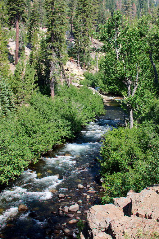
The early stretches of the San Joaquin River were striking in their own way, as well.
Within a half-mile of the hike, we were at Devils Postpile. I took this shot later, however, after climbing to its top. All I had to do to see that was to take a right, and climb.
The top featured one polygon or honeycomb shape after another--laid next to one another, like outdoor patio tiles.
In between were some more sparse sections, with forests still recovering from the 1992 Rainbow Fire, sparked by lightning, gale force winds, and drought. The landscape featured in the top photo was definitely shaped by the fire.
About 2.5 miles away, on trails that went out of the monument area and into the Inyo National Forest for a bit, came the area's Rainbow Falls. I took some rainbow-less photos of it around 11 a.m., before heading to the lower falls. When I passed by again, at noon, the rainbow had appeared.
I stuck my feet in the mighty cold water at the lower falls, and kept them there until I started noticing that they were getting numb. I watched crazy people swim in it--and dogs. But dogs have fur, so they get a pass. It was Canine Heaven, down there.
It was another 2.5 miles or more back to a place to get on a shuttle bus back to Mammoth Lakes (at Red's Meadow, an equestrian and mule train-oriented resort). I really can't remember! I do remember that, except in a few cases, visitors have to take a shuttle bus to and from the monument area in the summer.
After that, I had a pizza in Mammoth Lakes and soon headed out of town a bit, about 15 minutes out in the Owens Valley area (in between the Sierra Nevada and the White Mountains here), to the Whitmore Tubs Road, site of many a tub fed by natural hot springs in the area. The road sits in a volcanic caldera, a la Yellowstone. Boiling water and geysers are located near where I was in the photo below, the Rock Tub Hot Springs.
Use of the tub is free, open to all, complete with views of the Eastern Sierra. Ten minutes in there, and my pores were completely unclogged. The road there is... Well, interesting, and shaky. Definitely shaky. I took a couple of wrong turns too. There were old coots and dudes out there RVs, just hangin' out.
Credits:
2018, Ray Mikell