In 1987, the Great Lakes Water Quality Agreement designated 31 Areas of Concern (AOC) in the United States. AOCs are Great Lakes tributaries with significant pollution and habitat problems.
With funding from the Great Lakes Restoration Initiative, AOCs are getting cleaned up and habitat is being restored.
An ecological investment is bringing life back to the aquatic environment. Tourism, recreation, and development are returning to the basin’s rivers, harbors, and lakes.
Revitalization breaks through in this photo essay from National Geographic photographer Peter Essick, in collaboration with the Great Lakes Sea Grant Network, demonstrating the renewed majesty of the Great Lakes and focused energy of AOC communities to bring people back to the water.
Every Great Lakes state has at least one ongoing or completed AOC cleanup or habitat project. While these communities have much in common—a history of legacy pollution and new challenges going forward—each has a unique story to tell.
Cuyahoga River Area of Concern
Northeast Ohio
Since then, the Cuyahoga River AOC committee has worked with the U.S. EPA and other partners to not only prevent more contaminants from entering the water, but also to remove legacy contamination from the sediments at the bottom of the river. These efforts are essential to addressing impairments along the river and restoring the Cuyahoga to its natural state.
The AOC committee has already registered successes. Public access to the water and aesthetics have improved, and the fish are safer to eat. The Flats, a former industrial area in downtown Cleveland, has become a thriving neighborhood that includes residential buildings as well as shops and restaurants. The Cleveland Metroparks also recently opened public slips near the Merwin’s Wharf restaurant, giving people direct access to the Cuyahoga with their own rowboats and kayaks, making the neighborhood a great example of balancing business development and recreation with the ecological integrity of the river and its inhabitants.
The work of restoring the Cuyahoga River continues. The EPA Great Lakes National Program Office is collaborating with the AOC committee and other partners on the potential removal of the Gorge Dam near Cuyahoga Falls, about 30 miles upriver from Lake Erie. That removal would have a huge impact on the river, including restoring its natural flow, enhancing fish habitat, and improving the health of wildlife that depend on the river.
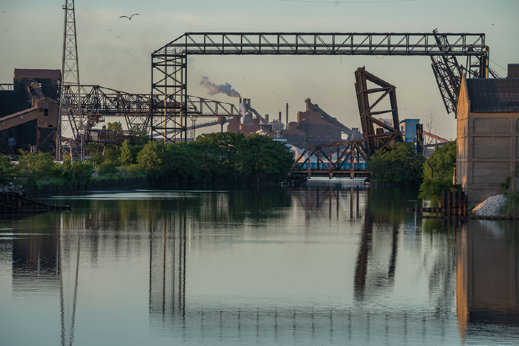
Detroit River Area of Concern
Southeast Michigan
The river’s shorelines have been hardened and reshaped to make room for massive industrial complexes. The riverbed has been carved up for shipping traffic. Environmental regulations like those outlined in the Clean Water Act have substantially reduced point-source pollution, but decades of chemical and heavy metal contamination hide in river sediments, slowly leaching out to degrade river quality and fish health. These factors, among others, led to the Detroit River being declared an Area of Concern.
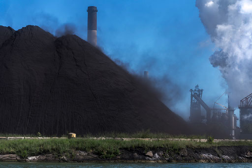
Grand Calumet River Area of Concern
Northwest Indiana
Globally important remnants of very diverse natural areas, like dune and swale habitats, have endured alongside all this activity.
“People are now more aware of the impacts of industry on human health and the environment,” said Paul Labus of The Nature Conservancy. “We are still working through what a healthy balance will be in terms of decisions about the landscape.”
Niagara River Area of Concern
Western New York
Development and industry in the past several hundred years have severely altered the habitat and water quality in the Niagara River AOC. This long history of development, contaminated discharge and sediments as well as proximity to hazardous and Superfund sites has led to habitat degradation and challenges to the survival of aquatic life.
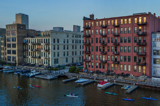
Milwaukee Estuary Area of Concern
Southeast Wisconsin
Milwaukee is known for many things—beer, music festivals, and gemütlichkeit, a German word reflecting the city’s traditional dominant ethnicity and meaning goodwill. Historically, it has also been known for its skilled manufacturing industry with factories turning out massive products like turbines, cranes, rail cars, and farm machinery. In the early part of last century, it earned the moniker “machine shop to the world.”
Another revitalization success story is Lincoln Park in the northern section of the AOC, which has undergone sweeping habitat restoration as well as remediation. Beloved by area residents, this park spawned a friends group that conducts numerous community gatherings, including a Weed-Out event tackling nonnative species.
St. Louis River Area of Concern
Eastern Minnesota
The St. Louis River Estuary can be described as wilderness in the heart of a concrete jungle. Slicing Duluth, Minnesota, from Superior, Wisconsin, at the western tip of Lake Superior, its water defines the border between cities and states. This 12,000-acre freshwater complex of wetlands, streams, and bays encompasses the nation’s busiest bulk inland port, the cultural history and current practices of the Anishinaabe, sport fish habitats, and an AOC.
Biologists and volunteers have worked to restore the sturgeon population. Municipalities, businesses, and residents have reduced the amount of nutrients and sediment that reach the estuary after storms. Scientists have confirmed that fish are no longer developing tumors at troublesome rates, and agency staff members are involved in lifting the related beneficial use impairment for the Area of Concern. Alongside those dedicated to restoring the health of the AOC, residents, taxpayers, and non-profit organizations are also playing a role.
Aspirations for removing the AOC designation by 2025 seem to be coming true. Wild cards lurk in this scenario, however. Extreme storms are becoming more common. The runoff from one gully washer can deliver staggering amounts of sediment, nutrients, pollutants, and damage in less than 24 hours, which could undo habitat restoration projects, improved water quality and other remediation progress. Changes in Earth's climate could undo much more over the next decade. Warmer and wetter conditions could lead to murkier water, more beach advisories due to higher bacteria counts, toxic blue-green algae blooms, and shifts in the aquatic food web.
Waukegan Harbor Area of Concern
Northeast Illinois
The Waukegan community has finally been able to turn the page on the legacy of industrial pollution along its shores that is such a familiar story in the Great Lakes region and the nation. Revitalization has begun to take shape in the harbor.
At a site that was once viewed as a health risk, the city now hosts 15 waterfront festivals every year that attract more than 250,000 people and give local businesses a boost. On the beach, more than 130 public activities take place—from morning yoga to evening concerts. Beach parking permits often sell out on the weekends.
Moving forward, with input from the community, the city has developed a master plan for the harbor and its connection to nearby downtown. The plan focuses on enhancing land use, environmental stewardship, and economic development of Waukegan Harbor.
Presque Isle Bay Area of Concern
Northwest Pennsylvania
Presque Island Bay is a small but vital body of water that lies between the Lake Erie shoreline and a 7-mile curved island, Presque Isle State Park in Pennsylvania. The story of this AOC began over 200 years ago when the city of Erie found promise and prosperity as a major shipping port and manufacturing hub. Industrial and domestic wastewater was discharged directly into the bay and local streams, often located in close proximity to drinking water intakes, resulting in serious health issues for residents. The bay was polluted with excessive nutrients, organic compounds, and heavy metals in the sediment.
By the early 1980s, public concern over contamination in the bay was at an all-time high. Anglers regularly caught catfish with tumors or other deformities, and dredging activity led to suspended contaminants in the water. The Erie County Environmental Coalition, a citizen group dedicated to restoring and protecting a swimmable Presque Isle Bay, traveled to other Great Lakes, held public meetings and workshops, and met with state and federal decision makers, leading to its designation as an Area of Concern in 1991.
In 2013—after decades of research, wastewater treatment system upgrades, increased environmental regulations to protect clean water, and continued community engagement—Presque Isle Bay was removed from the AOC list.
The Great Lakes are having a moment.
The ecological investment of the Great Lakes Restoration Initiative (GLRI) has restored thousands of acres of habitat and cleaned up millions of cubic yards of contaminated sediment in Areas of Concern. As evidenced across the eight states that call the Great Lakes home, the region is experiencing a natural resource revival. And the benefits of GLRI extend past the water’s edge to revitalize AOC communities. These restoration projects produce significant economic and social benefits in AOCs, yielding $3.35 in economic activity for every $1 spent through increased property values, tourism, recreation, and quality of life. AOC communities are hard at work to make this moment last.
Credits
Photography
Peter Essick
Photos for this project were made possible in part by a grant from National Geographic Society. © Peter Essick. These images are protected by copyright law and may not be copied or reproduced without prior permission.
Production
Hope Charters, Illinois-Indiana Sea Grant
Writing
Hope Charters, Illinois-Indiana Sea Grant
Irene Miles, Illinois-Indiana Sea Grant
Caitie Nigrelli, Illinois-Indiana Sea Grant
Christina Dierkes, Ohio Sea Grant
Jill Jentes, Ohio Sea Grant
Geneva Langeland, Michigan Sea Grant
Paul Focazio, New York Sea Grant
Moira Harrington, Wisconsin Sea Grant
Sharon Moen, Minnesota Sea Grant
Kelly Donaldson, Pennsylvania Sea Grant