Loading

Explorations in Hydrogeology and Climatology University of Alaska Anchorage

This is the research page for the work of Dr. Eric Klein, his colleagues, and students. Our research explores the interface of water, geology, and climate in high northern latitude regions.

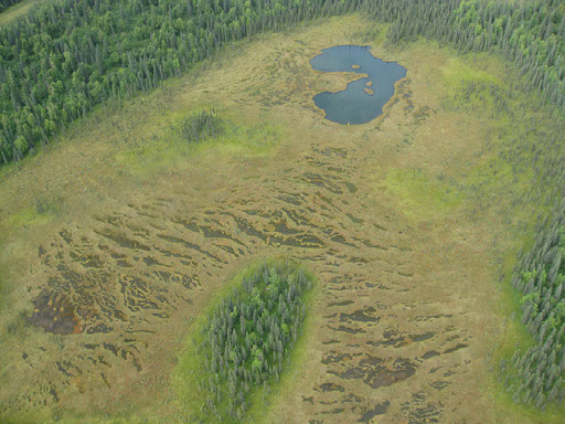
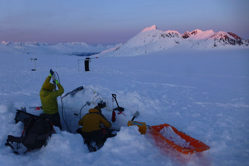
We are interested in how water moves through the Earth and can leave different signals (some physical, others biological or chemical) that allow us to understand its distribution and impacts across multiple time periods, landscapes, and phase changes. We use field instrumentation and stable water isotope ratios to understand the movement and relationship between modern hydrogeological variables, such as precipitation and water table depth. These modern data can help place historical changes in context, as we also study the response of paleo Earth systems, such as lakes and glaciers, to hydroclimate variables through environmental reconstructions using multiple proxy records.

Collecting field data in drying lakes on the Kenai Peninsula, Alaska.
water cycling, Peatlands, and paleoclimate in the shadow of denali and the alaska range
Alaska Range glaciers can influence regional hydrology and create rivers rich in glacial sediment. The Susitna River Basin region is also covered by a vast array of lakes and peatlands. Some of the peatlands, which accumulate carbon as partially decomposed organic matter, have beautiful patterns created by hydrogeologic processes.
Studying how the Kahiltna Glacier in the Alaska Range (above) and surficial geology impact peatland hydrology and carbon accumulation during changes in climate. Both modern instrumentation (e.g., water table loggers) and sediment cores help examine these processes. A light colored tephra layer, from a volcanic eruption, is seen in this core.
Collecting permafrost peatland sediment cores for paleoclimate reconstructions off the Niukluk River on Alaska's Seward Peninsula. Permafrost thaw forms thermokarst lakes and drops the land surface, with the prior level shown where our field colleague stands.
Collecting sediment cores, near a well installed to gather modern groundwater data, for paleoclimate reconstructions from a forested peatland in Southern Estonia. These peatlands are rich in Sphagnum moss and exhibit relatively high carbon accumulation rates.
water vapor isotope measurements at Toolik Lake, Arctic ALaska
Continuous measurements of Arctic water vapor isotope ratios and meteorologic conditions at this station near Toolik Lake are influenced by many parameters: the Brooks Range mountains to the south, the amount of snow and ice cover on the landscape, and the large expanses of polygonal features to the north. Regional water cycling and climate patterns can also be influenced by the Arctic Ocean.
Summer field work in the Brooks Range and North Slope of Alaska also offers numerous opportunities to interact with, and donate blood, to mosquitoes. At least I am also creating food for migratory birds.
arctic sea ice, water isotopes, and hydroclimate
Real time, high frequency analyses of water vapor and surface water isotopes aboard mobile platforms, such as the USCG icebreaker Healy, allow for new insights into how changes in sea ice impact the Arctic water cycle.
USCGC Healy breaks through sea ice in the northern Chukchi Sea: Understanding the influence of sea ice on water vapor isotopes at moisture sources allows for new interpretation of paleoclimate records, such as those in Greenland ice cores.
In collaboration with the USGS we are using water and snow isotopes to explore how hydroclimate changes impact mass balance on Wolverine Glacier and meltwater discharge into regional rivers, aquifers, and Prince William Sound.
Working with the Juneau Icefield Research Program, we are using water isotopes to investigate past, present, and future hydroclimate patterns across the Juneau Icefield (in southeast Alaska and Canada), as well as Icefield water cycling though drainage rivers and groundwater.
exploring water cycling patterns with water isotopes in northwestern greenland
A combination of meteorologic instrumentation, continuous water vapor isotope ratios, and various field water samples are helping us understand how changes in the Greenland Ice Sheet and Arctic sea ice are influencing the water cycle in the rapidly changing high Arctic.
Created By
Eric Klein
Appreciate

Report Abuse

If you feel that this video content violates the Adobe Terms of Use, you may report this content by filling out this quick form.

To report a Copyright Violation, please follow Section 17 in the Terms of Use.